
Fun Silly New L.A. River Kayaking Video
December 10, 2019 § Leave a comment
Enjoy this new video from a couple of intrepid folks who recently attempted to kayak the L.A. River… and didn’t get very far… but nonetheless made a fun video showing their experience. They put in near Griffith Park’s Bette Davis Picnic Area – at the edge of the city of Glendale’s Glendale Narrows River Walk and only got to the adjacent Griffith Park Ferraro soccer fields.
There are plenty of places to put in and kayak the L.A. River safely and enjoyably – see my 2008 account of my first kayak trip there: day1, day2 and day3. The Burbank and Glendale stretches do involve plenty of portaging (walking.) There are also various organized kayaking tours these days. One warning: the L.A. River can get very dangerous very quickly during rainy weather, just watch No Way Out. The best time to kayak is when it’s not raining.
Reflections on River Access
October 4, 2012 § 2 Comments

Sepulveda Basin: Great Blue Heron and Kayakers, Summer (painting by Joan Wolfe ©2012)
As the heat of summer slowly (hopefully) begins to wind down, so too has the second season of the pioneering L.A. River kayak and canoe excursions. The final group dropped into the River this past Sunday, an undoubtedly leisurely paddle between willows and sycamores, shopping carts and plastic bags. The 2012 installment hosted approximately 2,000 participants, an impressive increase from 2011, when the count for the pilot program was 260. The number of outfits operating on the River has also doubled and now includes Paddle the L.A. River (organized by L.A. Conservation Corps, MRCA, The River Project, FoLAR and Urban Semillas) and L.A. River Expeditions (organized by George Wolfe and the San Joaquin River Stewardship Program). I had the pleasure of paddling with both groups as a guest educator (thanks to Melanie Winter and George Wolfe for getting me out there!), a journey every Angeleno within reach of a buoyant non-motorized vessel should be able to experience at least once. « Read the rest of this entry »
News and Upcoming Events – April 9 2009
April 9, 2009 § Leave a comment

Wetlands Dream quilt by artist Linda Gass - click image to see more of her work - copyright Linda Gass
Creeky News:
>Rainwater harvester Brad Lancaster tours the Tujunga Wash Greenway and Stream Restoration Project. More on the water harvesting front: Alternet tells about multi-benefit rainwater harvestingin Africa; the L.A. Times explores harvesting rainwater in Downtown Los Angeles. Lancaster’s blog features a very good guest blog entry by Julia Fonseca critiqueing the use of crushed rock (decomposed granite.)
>Frederick Reimers‘ excellent article about the Los Angeles River kayak expedition is finally on the web (after appearing in print last December in Plenty magazine).
>Minnesota Public Radio talks about why the Red River floods Fargo. (Thanks Judith Lewis.)
>The L.A. Times reports that California may approve new more civilized greywater regulations. Creek Freak Joe Linton is still loving his unpermitted greywater system.
And for bridge geeks only:
>Bridge Photo of the Day blogger is working his way down the Los Angeles River
>Is Pasadena’s Colorado Street Bridge over the Arroyo Seco haunted?
Freaky Events:

Cheong Gye Cheon river in Seoul South Korea - Photo: Wikimedia
Dr. In-Keun Lee, Assistant Mayor of Infrastructure of Seoul, South Korea, will be giving a talk about the dramatic revitalization of the Cheong Gye Cheong. Seoul, South Korea, actually removed a dozen lanes of double-decked highway to daylight the historic creek that was buried below. The free open-to-the-public talk takes place from 2:30pm-3:30pm on Friday April 17th, 2009 at the Edward R. Roybal Board of Public Works Session Room (Room 350) at Los Angeles City Hall – 200 North Spring Street, Los Angeles, California 90012. Entrance is on Main Street. Easy access from the Metro Red Line Civic Center Station.
Bloggers Joe Linton and Damien Newton teach you how to use lots of cool free stuff on the web at our Internet Skills Class on Tuesdays April 21st and 28th.
President Obama invites you to clean-up the Los Angeles River at Taylor Yard on Saturday April 25th. Then go back and do it again at Friends of the Los Angeles River’s La Gran Limpieza at more than a dozen sites on Saturday May 9th.
Bike the Emerald Necklace on the San Gabriel River and the Rio Hondo with the city of El Monte’s Tour of Two Rivers bike rally on Saturday May 16th. Then bike the Los Angeles River on the Los Angeles County Bicycle Coalition’s River Ride on Sunday June 7th.
News and Upcoming Events – December 12 2008
December 12, 2008 § Leave a comment
Lots of fun things happening these days on our local creeks and streams! We’ve varied our format, because there are two important meetings next week that you won’t want to miss:
The city’s proposed River Improvement Overlay or “RIO” zoning (Creek Freak coverage here) will be the subject of a public hearing on Monday December 15th at 8am at Los Angeles City Hall, Room 1020, 200 North Spring Street, Los Angeles 90012 (entrance is on Main Street.)
The Environmental Protection Agency’s ruling on whether the Los Angeles River is navigable will be subject of meeting hosted by Friends of the Los Angeles River at 5:30pm on Tuesday December 16th at the Los Angeles River Center and Gardens, Atrium Room, 570 W. Avenue 26, Los Angeles 90065. The EPA’s David Smith will be present. If you made it through Creek Freak’s 4-part magnum opus on Nexus and Navigability, you’ll no doubt want to attend!
And there’s the recent news:
Kayaker Case Settled: Heather Wylie kayaked the LA River and was threatened with suspension from her job as a biologist for the Army Corps of Engineers. Earlier this week, she settled her case. She’ll be leaving her job and going to law school with plans to become an environmental attorney. Read the Public Employees for Environmental Responsibility press release here, and for some background on the case, check Creek Freak’s earlier coverage. Important hearing on navigability next week – see below.

Earthen Bottom Stretch of Compton Creek (Photo: Los Angeles and San Gabriel Rivers Watershed Council)
Comtpon Creek Flowing: The city of Compton and the Mountains Recreation and Conservation Authority are moving forward with the Compton Creek greenway. Read the Los Angeles Wave’s coverage.
Green Advocate Empowered: Mayor Villaraigosa has appointed Green L.A. head Jonathan Parfrey to the 5-member Department of Water Power Commission. Parfrey is a friend of mine, the executive director of Green L.A. Coalition, and a committed and knowledgable environmentalist. Read the LA Times’ blog.
Land Swap Troubled: Remember that Long Beach land swap (Creek Freak coverage here) that preserves the Los Cerritos wetlands? Well, the down economy is impacting it, and the developer is looking to back out. Read Long Beach Press Telegram coverage.
Trout Passage Bridged: Though the fish apparently like it, some Malibu residents are unhappy with the reworking of the Solstice Creek Bridge. Read The Malibu Times’ coverage.
San Gabriel Fished: A new Urban Fly Fishing blog tells us the sweet fishing spots on the San Gabriel River.
Economic Stimulus Greened: In this LA Times editorial, TreePeople’s founder Andy Lipkis urges us to make sure that the federal economic stimulus infrastructure projects are smart and green.
Blue is Green: This New York Times blog proclaims that “blue is the new green” and has some beautiful images of green roofs and walls, water harvesting and gray water.
Río* from B a s t a r d i l l a on Vimeo.
Río Bogota Blues-ed: This video from the band Aterciopelados re-imagines the polluted urban Río Bogota. It’s full of beautiful animated drawings by the grafitti artist Bastardilla. (Thanks to correspondent Federico via the Wooster Collective blog.)
and, lastly, an annoucement:
Creek Freak wants you! If you’re interested in volunteering to help LA Creek Freak get the word out about LA’s worthwhile waters, let us know. We’re looking for guest bloggers that can cover subjects that Jessica and I can’t get to. Also, much needed are photographers! If you can let us use your existing river images, or can go out and photograph sites that we’re writing about, let us know. Email us at lacreekfreak {at} gmail . com!
Of Nexus and Navigability, Part 3: The Boater, the Biologist, and the Blogs
December 1, 2008 § 2 Comments
Prologue
Creek Freak continues our exhausting alliterative four part series on the navigability rippling through the waters of the mighty Los Angeles:
Part 1 – Of Nexus and Navigability, a lament for our waterways
Part 2 – Journalistic Journeys
Part 3 – The Boater, the Biologist, and the Blogs
Part 4 – Action Alert
Of Nexus and Navigability – Part 3, The Boater, the Biologist and the Blogs
By way of background, federal waterway protections are being weakened through recent governmental decisions. For the federal Clean Water Act to protect a river, creek or stream, it must be a “traditionally navigable waterway” or have a “significant nexus” to one. See Part 1 for more detailed background and historical accounts of boating. See Part 2 for some 20th century accounts of boating. And this blog is where we bring boating into the present day.
A couple years ago, while I was working at Friends of the Los Angeles River (FoLAR), I got an email from George Wolfe who runs the Lala Times – a website mostly humor/parody site that bills itself as “California satire, wierd and bizarre news.” I have to confess that, at first, I mistakenly thought that I had been contacted by the LA Times and was always quick to respond to media requests. I soon spoke with George, a boater (who kayaks and canoes) with a idea to do a big expedition down the Los Angeles River.
George and I kept in touch. At one of our lunches discussing possible expedition parameters, he pulled out the most raggedly well-used copy of my book that I’d ever seen. He’d done a lot of advance scouting and even some negotiations with the County Flood Control District and the Army Corps. of Enginneer to permit the trip. The date was set for July 25th-27th 2008.
I met up with George for a trial run a week ahead of the expedition. We put in just below the Los Feliz Boulevard Bridge and kayaked down to the best rapid on the whole river, just below Marsh Park in Frogtown. Under the tutelage of FoLAR’s Denis Schure, I had been in a kayak a couple of times briefly in a calm nearly-currentless stretch of the Los Angeles, adjacent to Balboa Boulevard in the Sepulveda Basin. After kayaking that sweet well-flowing natural stretch with George, I was excited and hooked at how fun it was! I was disappointed in myself that I had been around the river all these years and hadn’t boated there often.
The three-day expedition was a blast. You can read my blog account of it here: Day 1, Day 2, and Day 3. There is a fair amount of documentation now online, including this recent trailer for a planned documentary feature about the trip:
Army Corps of Engineers biologist Heather Wylie accompanied the second day of the trip. She was later threatened with a 90-day unpaid suspension from work for participating. It turns out that her superiors didn’t know of her participation until they saw this photo of her posted on the LAist blog. Some links to her story are available here and an excellent editorial she wrote is linked here. Check out this short video where she tells you some of her stories:
The kayak expedition, in addition to being lots of fun and a great workout, proved to me personally that the vast majority of the Los Angeles is indeed very navigable. There are a few spots that required some portaging, mostly in the San Fernando Valley, but certainly all the way from the 134 Freeway downstream to Long Beach are easily kayaked any day of the year. Contrast this with the Army Corps of Engineers’ designation of only two short stretches (in the Sepulveda Basin and in Long Beach) as navigable. We’ve still got a long way to go in convincing our public agencies to respect the Los Angeles River.
Next: Part 4 – Action Alert – wherein you, the reader, take action on assuring federal protections for western waters. **12/3/2008 – Correction: this is an important meeting that’s still happening – but it’s not about navigability. Navigability meeting is a different one planned for December 16th – more info about that soon! Also, plan to attend the city of Los Angeles’ public meeting this Thursday night from 5:30pm to 8:30pm at the Metropolitan Water District in downtown Los Angeles. The meeting will include a presentation on and an opportunity to comment on the navigability issues.
Of Nexus and Navigability, Part 2: Journalistic Journeys
December 1, 2008 § Leave a comment
Prologue
Los Angeles River navigation is a critical issue right now! It’s not just about defiant kayakers, but about ensuring federal waterway protections prevent all our waterways from further degredation. Jessica has already done one post on this, but now Creek Freak is expanding our coverage into a four part series. If you’re not already familiar with this issue, you might want to go back and read Part 1 before reading this entry.
Part 1 – Of Nexus and Navigability, a lament for our waterways
Part 2 – Journalistic Journeys
Part 3 – The Boater, the Biologist, and the Blogs
Part 4 – Action Alert
Of Nexus and Navigability – Part 2, Journalistic Journeys
The reason that navigation is important today is due to legal wrangling over interpretations of the federal Clean Water Act and which waterways are deemed important enough to receive federal protection. For an explanation of the navigability issue, see Part 1, in which Jessica’s fills in the background and boating’s early history. Her account covers the historical records from the 1800’s.
This blog shares some 20th century journalistic forays into Los Angeles River boating. Though these accounts do offer evidence that the river is navigable, the overall tone of the articles are rather mocking – as in how big a surprise it is that anyone would be boating on such a river. See Part 3, and bringing the situation up to the present date with some wrap-up coverage of the recent kayak trips and recent developments regarding official determinations regarding whether the river is navigable or not.

April 1st 1925 Los Angeles Times Los Angeles River boating article with "Pictorial Evidence Presented to Skeptical Public.
On April 1st 1925, the Los Angeles Times ran an article entitled Scribe on Wonderful Trip: Cruises the Los Angeles from Griffith Park to Seventh Street Bridge; Skipper Admires Nature by Otis M. Wiles. In a very joking tone, the article tells the story of the intrepid correspondent and Skipper Ed’s journey in the good ship Mud Hen. Some excerpts:
“The Times exploration party set forth in a makeshift craft at eventide yesterday to explore the mystic splendors of our much-maligned river and prove to the world that it’s navigable.”
The journey through the Glendale Narrows sounds fairly nice. The article describes “tall green bullrushes” and “a staircase rapid resembling Angel’s Flight.” The river through downtown wasn’t quite as nice. The boaters encounter “several hobo camps” along the “wooded river bank.” Near the present day 101 Freeway, they pass “a city dump reeking with garbage smells … The dump was afire, clear to the water’s edge.”
“Your intrepid correspondent dumped the water out of his boots and came ashore, thoroughly satisfied that the Los Angeles River has been grossly wronged and maligned. It has water in it, contrary to all reports otherwise – wet water, cold water and muddy water. And it can be navigated. from Griffith Park to the Seventh-street bridge at least, in a seaworthy duck-boat if fortune favors the navigator in ducking rocks, bridges, sharp curves and railroad ties and sewer drains.”

Herald Express Reporters Boating the Los Angeles River in 1938
In March 1938, Los Angeles was hit with the worst floods on record. These were likely not the highest volume floods, but serious floods paired with increased development of the flood plains, resulted in widespread destruction. According to Blake Gumprecht, the 1938 floods caused eighty-seven deaths, and more than $78 million in damage, including washing out many buildings and bridges. As the floodwaters were beginning to recede, the Los Angeles Herald Express’ “Foghorn” Eldridge and “Wharf Rat” Watson (actually reporter Fred Eldridge and photographer Coy Watson, Jr) attempted a boating expedition from just below the Glendale Hyperion Viaduct (in Atwater Village) to the river’s mouth in Long Beach. Similar to the 1925 Times article above, their accounts mockingly echo adventure writing of their day. They didn’t quite get to Long Beach, but made it only about a half-dozen miles to take out in downtown Los Angeles. Photo above courtesy of the Los Angeles Public Library Herald Examiner Collection. Additional expedition photos are available there and in Arcadia Publishing Images of America series book Los Angeles River by Ted Elrick and the Friends of the Los Angeles River.

March 2nd 1958 Los Angeles Times Los Angeles River Boating Expedition Coverage
A later descent is chronicled in a March 2 1958 Los Angeles Times article Timesmen Explore Los Angeles River by Charles Hillinger. This tells the story of the reporter and cameraman who, in a 5-man inflatable boat, paddle bravely exploring the Army Corps of Engineers’ newly-completed concrete structures.
The Timesmen have difficulty putting in at the start of the river proper, behind Canoga Park High School. “Too shallow.”
They make their way downstream before putting in at a vague location: “Finally, in the heart of the city, we launched our boat.” From a later description that they took out around Firestone Boulevard after traveling “10 miles in five hours,” their put-in spot was likely near the Arroyo Seco confluence.
Boating down the concrete river, they describe “Deep water – a foot and a half – and we floated down the stream at a fair clip.” They run into issues in Vernon where “[m]ud and rocks dammed the main middle stream.” They walk and boat further until giving up around the Rio Hondo confluence where they give up “bogged down on sandbars, hiking through knee-deep mud.”
The pair rounds out their exploration by driving along the river. They describe visits to Sepulveda Dam, the east San Fernando Valley, and the Headworks Spreading Grounds.
In 1999 the LA Weekly ran a cover story Taming the Wild Trickle: A Gray-Water Adventure on the Mighty L.A. by Steve Chapple. Chapple, who kayaks the Yellowstone and the Zambesi, teamed up with Friends of the Los Angeles River’s longtime boater Denis Schure to make 3-day descent of the Los Angeles River from Reseda to Long Beach. Here are a couple of excerpts:
“This wasn’t white water, anyway. It was more like gray water. But runnable. Let me emphasize that. There was enough flow in the Los Angeles River from recent rains to make an experimental first descent possible, yet not so much that we would have to worry about Ralphs shopping carts tumbling end over end in the rainy-season roil and whacking us upside the head. This was a historic moment.”
“We rounded a bend and there stood the Glendale Freeway, crossing the Santa Ana. It was a stunning architectural tableau, Frank Lloyd Wright meets the slime. Arching steel. Pounding concrete. Below, the river concentrated itself in a new center slot that looked fast and deep. We positioned the canoe. Soon we were rodding along at maybe 10 mph before paddling (the paddles had paddles now), but the groove was unexpectedly shallow, all of 18 inches. Though I was distressed, yet again, to have been talked out of my beautiful touring kayak, I contained my cheap-thrill-seeker’s anger: For this was the place where Los Angeles began, a place of reverence. We paddled into the confluence with the Arroyo Seco, site of the original L.A. pueblo, now an unmarked graffiti hole.”
Earlier this year, the US Army Corps. of Engineers only designated two stretches as “traditionally navigable waterways.” These two stretches were: 1) the estuary below Willow Street in Long Beach and 2) the Sepulveda Basin. While none of the articles above describes every inch of the river as navigable, they do record journalists boating in stretches that the Army Corps hasn’t designated as navigable.
Next: Part 3 – The Boater, the Biologist, and the Blogs
For Your Viewing Pleasure: Turtles, Ballona Bikes, Dorothy Green and more!
October 25, 2008 § Leave a comment
Here are some on-line videos that all us creek freaks might enjoy:
>Los Angeles Times account of Aquarium of the Pacific’s healing and release of an injured San Gabriel River sea turtle (Great video – with fascinating x-rays of broken turtle flipper bones. Kudos to the great work of the Aquarium of the Pacific staff and the Times’ Louis Sahagun. There are also sea lions in the San Gabriel River.)
>KTLA news coverage of Ballona Creek Bike Path issues (via LA Streetsblog, includes Ballona Creek Renaissance’s Jim Lamm)
>Hook TV on How to fish for carp in the Los Angeles River
>Jeffrey Tipton’s Montage on the July 2008 Los Angeles River Boating Expedition organized by George Wolfe (Coming soon: an actual high production value trailer about this expedition. Also, check out George’s kayak commute video.)
>A group I don’t know about called LA River Story has done a somewhat accurate trio of documentaries beginning with San Fernando Valley tributaries: The Great Wall of Los Angeles Mural on the Tujunga Wash, the adjacent Tujunga Wash Greenway, and what they’re calling the beginning of the river in Chatsworth.
>Turn Here’s Down by the (L.A.) River (How many errors can you spot in Creek Freak Joe Linton’s brief appearance? Be grateful that I don’t plan to blog on restaurant recommendations any time soon.)
>Meeting of Styles Graffiti Murals Event (These murals were later painted out)
>Insidious Bliss (A bleak and beautiful documentary on crystal meth addiction and homelessness in the Glendale Narrows stretch of the L. A. River)
and lastly a couple of not entirely successful attempts at Los Angeles River Humor:
>Stewart Paap in search of the LA River (“Easy access, huh?”)
>Deep Sea Fishing in Studio City (My favorite part of this are the outtakes and the brief scene where the actor steps around the construction fence – I plan to blog soon about my frustration that the city of Los Angeles’ Studio City Riverwalk has been fenced off for more than a year.)
Recent News, Upcoming Events 2008 October 8
October 8, 2008 § Leave a comment
An occasional round up of the very creekinest items that come across my virtual desk:
Use a Kayak, Lose your Job: On October 8th the San Jose Mercury News reported that Army Corps of Engineers biologist Heather Wylie is threatened with a 30-day suspension because she participated in the recent Los Angeles River kayak expedition. “Her supervisors found out about it when they saw a photo of her on the kayak trip on the Internet, according to the notice of proposed suspension letter.” (Note that Creek Freak was jealous that the less-than-100-pound Wylie navigated the river so much more easily than I, who frequently scraped concrete bottom. Creek Freak’s trip blog here: day one, two and three.) *UPDATE Additional Links: Army Corps Suspension Letter (pdf) Public Employees for Environmental Responsibility (PEER) legal response letter (pdf) LAist Photo of Wylie from July 2008 LA River trip
“We have enough to live on, but not enough to waste”: On October 8th, the Los Angeles Times ran this editorial by Dorothy Green calling for sane and sustainable water policy. (Thanks Aquafornia)
Calabasas’ Award for Concrete Removal: On October 2nd, the Acorn reported that the city of Calabasas’ Las Virgenes Creek Restoration Project was honored by the American Society of Civil Engineers Metro Los Angeles Branch. Read about the project here.
Say It Ain’s So: On September 29th Blogdowntown reported that studies show that the 6th Street Bridge will need to be replaced. This 1931 bridge is magnificent. Creek Freek fears that city proposals to widen it into a mini-freeway will be a travesty. I hope to blog about this sometime soon.
Upcoming Events:
The city of LA’s Stream Protection public meetings continue, Friday October 10th (1:30pm at City Hall) and October 17th (7pm at the Marvin Braude Constituent Service Center in Van Nuys.) It’s important that environmentalists attend!
L.A. Unfolded: Maps from the Los Angeles Public Library opens at the Downtown Los Angeles Central Library’s Getty Gallery next week. Rumored to have some incredible old maps of the Los Angeles River, the exhibition will be on display from October 15th through January 22nd 2009.
The Venice Neighborhood Council, Heal The Bay, Santa Monica Baykeeper and others host a State of Our Ocean Town Hall Meeting – Thursday October 23rd at 6pm at Westminster Avenue School, 1010 Abbot Kinney Blvd in Venice.

Bike Ballona on October 25th
Concerned Bicyclists of the Ballona Creek host the inagural Tour de Ballona on Saturday October 25th departing at 11am at the Culver/Sawtelle entry to the Ballona Creek bikeway. CBoB came together to make the Ballona Creek bike path safer.
Jenny Price leads Friends of the LA River’s river tours: Sunday October 26th and Sunday December 7th. The December tour starts in Long Beach and marks FoLAR’s initial regular tour of the Lower Los Angeles River.
Join LA City Council President Eric Garcetti for A Day at the River – Saturday November 8th from 9-11:30am at Crystal Street Bicycle Park in Frogtown.
Urban Photo Adventures hosts Unexposed: the Los Angeles River photography tour on Saturday and Sunday November 8th and 9th. More of their great photos here.
Kayaking the Los Angeles River: Day 3
July 29, 2008 § 5 Comments
Day three was exhausting. We put in at Marsh Park in Elysian Valley and paddled our way to the river’s mouth in Long Beach. This is about 25 miles, more than 20 of which are three-sides concrete. A quick apology – I didn’t take any cell phone photos that day. It seemed like there were lots of photographers all over much of the time taking photos – see links at the end of the blog below for excellent photos – especially LAist and Ted Soqui. I did paint one watercolor of the river at Marsh Park, while we were running late on the put in.

Los Angeles River at Marsh Park
Marsh Park is located in the Glendale Narrows, pretty much the nicest stretch of the whole river. Due to groundwater coming up in this area, the bottom of the river is unpaved, so there are lots of tall willows, turtles, ducks, heron, egret, and more. It’s where people who visit for the first time gasp and say “wow – it is a river!” Also at Marsh Park are the best rapids of the whole river. It’s a short chute that has plenty of slope and plenty of flow. Very fun, but it also can capsize folks like me who haven’t had much kayaking experience. On a test run, a week in advance of the trip, I did flip my kayak, though on a second try and on the official expedition, I was able to shoot through it unscathed. A few of crew flipped and received a river baptism that morning. The trick is not to lean upstream, so the river doesn’t catch the lip of your boat.
The next two miles were very nice, despite a few spots where we’d get stuck among rocks and have to portage a bit. It’s plenty navigable, and very beautiful. I kayaked up at to two older Latina women and a man whom I chatted with a bit with. They said, in Spanish, that they were harvesting “yerba mora” and another plant, which they used to make soups.
Just upstream of the Riverside/Figueroa Bridge the soft-bottom stretch ends and the all-concrete canyon begins. We gathered the troops and spoke a bit about the historic confluence with the Arroyo Seco and a bit about safety, then started down the concrete low-flow channel.
We cruised under the great historic City Beautiful bridges. The North Broadway Bridge (originally and formally the Buena Vista Viaduct) located along the Cornfields is the great early progenitor of the series. It features some of the earliest compound arches made of concrete – a technological advance that made the understructure of the bridges lighter, though still majestic. As we went under each of the historic spans, I was noticing that as time progressed (ie: the later date that the bridges were built), the understructures become lighter and more airy. Unfortunately, as time progressed, these become so light that they skip the arch and just put the straight flat girder across.
There was a construction site at the First Street Bridge, where crews are widening the bridge to make space for more cars… er… I mean to make space for the eastside extension of the Metro Gold Line, while allowing for lots of cars. I am cynical about this because nearly all these bridges had streetcars running down them originally, and now when we want to run the trains down them again, the experts tell us that we have to tear out the original structures. The First Street Bridge widening isn’t as bad as some others proposed. I will write more about the threatened bridge demolitions in other posts later. We portaged around the low temporary construction bridges and continued downstream.
I was surprised at how shallow the low flow channel is. When I’ve led tours of the river, I get questions about how deep it is, and I’ve always responded that it’s 3-4 feet deep, based on seeing folks in it occasionally… but actually being in it, paddling a kayak, I now realize that it’s quite shallow. My paddle was frequently scraping bottom. It’s really only 1-2 feet deep. That doesn’t sound like a lot of water, but it’s enough to float a kayak – without much scraping – yay! It can still be a bit treacherous to cross on foot – the water is moving fairly fast and the sloped sides can be pretty slippery.
Near the Washington Boulevard Bridge and the start of the city of Vernon, the walls of the channel go from sloped (trapezoidal channel) to vertical (box channel.) The river makes a left turn. The smells get bad and the low flow channel splits and gets shallower. I had expected that we’d have to portage this area, but were able to float and scrape and get by. The walls go trapezoidal again and the central low-flow channel resumes where the river flows under Bandini Boulevard in Vernon.
I have to say that I was somewhat impressed with the stark featurelessness of the river below Bandini. Seems like nearly everywhere in nature there are differences and variety, but, here on the river in southeast Los Angeles, there is surprisingly little variation in slope – for miles. The engineers and the construction crews did a great job of creating a nearly entirely continuous smooth unrelenting gradual drop all the way from downtown to the ocean. There are a very few places where the slope increases slightly – very short drops, often after bridges, and one small chute around Southern Avenue in South Gate. If the slope were more uneven, perhaps there would be more problems with sediment settling out of the water. It’s an impressive feat of engineering.
I was also impressed with how nature is reclaiming the river. In many places, from the mouth of the Arroyo Verdugo, to just upstream of Willow Street in Long Beach, there’s a fair amount of vegetation growing either through the cracks or on a layer of silt atop a concrete bottom. Most of the vegetation is opportunistic weedy, but there are occasional cattails and even willows. Even in middle of Vernon (at a location I don’t want to disclose for fear of alerting the flood control bulldozer crews), I saw a 10-foot tall willow tree growing out of the concrete along the low flow channel. This vegetation creates eddies, slowing down the water, causing it to deposit sediment, building up sandbars and making way for more vegetation. It’s nature’s cycle of reclaiming disturbed areas. Microorganisms move in, then bugs, then ducks. It’s great to see it starting to happen in the concrete moonscape areas downstream.
We stopped for lunch at Maywood Riverfront Park, located at Slauson Avenue. I checked out the now-open park; its opening had been delayed for years due to concerns over possible contamination from a chemical factory that occupied a portion of the site. There were lots of families enjoying their Sunday afternoon and the recently-very-pristine ball fields were showing signs of plenty of use – a good sign in my book. The adjacent mini-park built by North East Trees looked good too, though it’s clear that the battle against graffiti has resulted in a lot of beige paint coating the river rock retaining walls.
We continued downstream. The concrete gets pretty relentless. Though I am not a big fan of them, I was actually really glad to see the Adel Rakhshani murals in the city of Paramount, as they helped break up the unrelenting grayness of it all.
There were quite a few birds hanging out in the all-concrete channel, including black-necked stilts, gulls, ducks, killdeer, and occasional herons and egrets. Closer to the ocean we saw more shorebirds – a few different types that I am not too good at identifying. As Jeff Tipton and I kayaked under a bridge, one black-necked stilt, with three cute small stiltlings in tow, became very animated. She (I am assuming it was a female) shrieked and flew near us, keeping just ahead of us, seemingly trying to draw our attention to her and away from her kids. Small families of ducks would swim in the channel. When l saw them downstream in front of me, I would kayak faster to catch up with them. The mother duck would corral her youngsters getting them to do their wobbly half-runnning double-speed maneuver to evade their pursuer. The ducklings would pop underwater to get away as I passed them. My other trick to punctuate the monotony of the lower river would be to paddle strongly to each bridge, then to slow and coast and rest in the precious shade underneath.
The way was only slightly punctuated by passing landmarks that I was familiar with. In the city of South Gate, the river’s confluence with the Rio Hondo was very anonymous. I almost didn’t notice it. The broad channel hardly contributed any flow to the LA River. The historic 1937 concrete-railing Atlantic Boulevard Bridge marked our entry into Long Beach. I thought that, at least, now we could say that we’d made it to Long Beach… though we still had a good half-dozen miles to go. Soon thereafter we passed the mouth of Compton Creek.
The concrete bottom ends at Willow Street in Long Beach. The river widens a bit more there, so the engineers added features to create turbulence to make the river spread out to to it’s full width. Before the bridge are a series of concrete block baffles. Unfortunately this meant another short portage. Where the concrete ends and the estuary begins is a fairly good looking place when you’re walking and bird-watching above it… but when you’re down in the water, it’s kinda nasty. This is another thing I learned from this trip. At the very start of each of the three areas where the concrete ends (below the Orange Line Bridge in Sepulveda Basin in the San Fernando Valley, at Bette Davis Picnic Area, and at the estuary in Long Beach), there are nasty smelling areas with duckweed and small bubbles of foul-smelling gas surfacing. When I stepped in the sediments in these areas, my foot sunk down into the quicksand-like sediment sending up clouds of gunky black cloudy water.
We pushed on down a very nice short rapids and came into the tidal zone of the river. Signs on the bridges told us that all kinds of activities weren’t allowed here, but that if we did them, we’d have to keep within a 5 mph speed limit. We saw more cormorants, herons, pelicans, and occasional fish jumping out of the water.
The sun was beginning to set as we rounded the final bend and caught sight of the Queen Mary. Lots of families were fishing from the breakwater. We passed beneath the Queensway Bay Bridge, pulled up along the breakwater and pulled out at Shoreline Park. Families and friends were there to greet us. We began to tell our tales and to speculate on future trips down our very navigable local waterway.
Here are some links to trip photos/articles/blogs:
Kayaking the Los Angeles River: Day 2
July 27, 2008 § 2 Comments
The second day of kayaking, in which the crew puts in at the Sepulveda Dam and takes out in Frogtown, was considerably more exhausting than the first. If this entry is shorter than the last, it’s because the day was longer.
On my bus ride in, I spied a gentleman across from me reading the Daily News. I asked to look and sure enough there were photographs and a very short text about the kayak expedition. The print edition even features this photo of me. Folks have mentioned that the L.A. Times also ran a photo… but I can’t seem to find it on their website.
There was a delay in getting things going at the preordained 9am start time, so Connor Everts and I put in at Burbank Boulevard and cruised our kayaks back upstream into the Sepulveda Basin. We saw ~5 carp, plentiful heron and even a turtle. Urban nature writer extraordinaire Jenny Price gave her talk. I’ve heard it before, but I really like what she says about the river. Take one of her tours if you get the chance. And we were off.

First portage (that’s where you walk, dragging the canoe… not all that fun) was immediately under the Sepulveda Dam. These photos are from my cell phone, which I really did want to keep dry, so I didn’t take too many and only in places where there wasn’t too much water splashing. I like to run more pictures of the greener parts of the river, but I was busy kayaking there, so you’re getting concrete shots today.
We were able to kayak through much of the East Valley – Sherman Oaks and Studio City. Not a great deal of water, so there was some scraping, and occasional brief portaging. We encountered a truck of county maintenance workers in the channel. I showed them my saran-wrapped sign stating “FILM PERMIT”, with the permit number, and they let us continue unmolested. We stopped for lunch at the ramp at Coldwater Canyon Avenue. Folks were in good spirits. The channel hadn’t been easy, but not too difficult.
Just east of Radford Avenue in Studio City (at CBS Studio Center), the flat bottom channel that we had been traversing gives way to what’s called a low flow channel. It’s basically a notch in the middle of the flat concrete channel, especially designed for fast, easy kayaking… er… I mean… designed to keep the flow in one place to make for easy maintenance. The initial lip of the low flow channel can be a little tricky, potentially dangerous – sort of a stair-step waterfall rapid. We took our kayaks out before it, lowered them in after and were on our way. At the east end of CBS, the Tujunga Wash meets the L.A. River. Visible from the Colfax Avenue Bridge, it’s a sort of wye made of notches, easy to shoot though on a kayak.
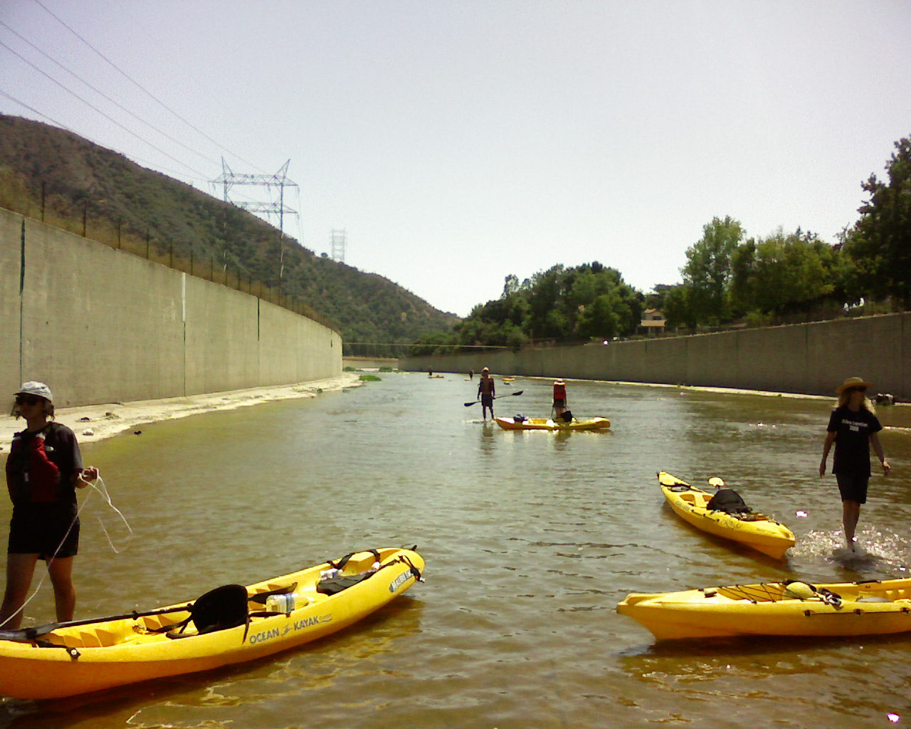 The low flow channel water moves fast, and it’s actually plenty deep, so it was certainly the most pleasurable and fastest moving part of today’s leg, though I found myself paddling quickly and sometimes bouncing off the sides, until I got the hang of it. The things you can do in a rental canoe! All good things must end… and the low flow channel peters out in the area around Forest Lawn. The picture at the left is looking back (west) upstream, with the Griffith Park hillside on the left and Burbank on the right. We then walked about a mile, canoes in tow, until we arrived at the soft-bottom stretch alongside Bette Davis Picnic Area. We were greeted there by supporters who buoyed our spirits with ice cream and cold drinks (thanks Ramona of Friends of the LA River!).
 And this is where our troubles began… Most of the folks were smart and decided to portage (via truck) down to Atwater River Walk. But a few intrepid (or perhaps foolhardy) souls continued in the channel. The next couple miles either contain lots of rocks positioned perfectly to immobilize foolhardy (or perhaps intrepid) kayakers, or, like the photo on the left, have expansive flat areas with only a few inches of sheet flow. The picture shows Jeff Tipton portaging before the 134 Freeway. The shot is downstream, where you make a right turn and can actually start to see the downtown skyscrapers in the distance (though you need a better camera than my cell phone to prove this… you’ll just have to take my word for it.) Griffith Park is on his right and the Arroyo Verdugo (which runs through Glendale) is on his left. Just downstream (a mere 15-minute walk), there’s a rocky area that looks like it should be kayakable… but I kept going for about 20 seconds before getting caught on rocks. I ended up pulling out and towing my boat on the east side of the river. I would see an area that looked good, put back in, then get stuck again. Perhaps a lighter and/or more experienced kayaker could navigate it better. I found it pretty frustrating.
Just downstream of Colorado Street, the Los Angeles-Glendale Water Reclamation Plant pumps out about 3 million gallon a day of tertiary treated water… and the kayakers are back in business… albeit exhausted by this point. We continued downstream, under the Los Feliz Bridge (another brief portage) then met up with the rest of the group. A police helicopter was circling overhead, and two uniformed LAPD officers greeted us at the Sunnynook Footbridge. They had received a call. I showed them the magic aumulet… er… film permit and they looked it over and over and asked to see it again and conferred and looked again… and told us we could proceed. (One of them told us that he’s a kayaker.)
The stretches below the LA-Glendale Plant are very pleasant. There are areas where you get trees and other vegetation on both sides and it feels like you’re not in L.A. anymore. Once we passed under the Glendale-Hyperion Bridge, we were greeted by a tribe of mudpeople (surreal tribal L.A. performance troupe) and another group of dancers (a group I don’t have the name for) all dressed in flowing white dresses. We lingered and spectated, then continued downstream.
We crossed under the Fletcher Drive Bridge. In the deeper (comparatively) water area under and downstream of the 2 Freeway, we encountered families, couples and individuals sitting on the sloped concrete wall with their fishing lines in, waiting. We asked and it sounded like folks hadn’t caught much that day, but they appeared to be having fun – hanging out, pointing at the nutty gabacho kayakers scaring off their carp.
We took out at Marsh Park where Mountains Recreation and Conservation Authority staff were telling stories with a dozen kids around a campfire. I am sore and tired… but I will be back out on the Mighty Los Angeles at 9am with my prow pointed toward Long Beach.
