
Dry weather diversions – memories up a sh*t’s creek
December 29, 2021 § 3 Comments
Yesterday’s post hurt my brain to write, and it hurts my brain a little to re-read. OK, it hurts my brain a lot. So I suspect it’s not fun for anyone else either. I wish it could be more straightforward.
And then I woke up this morning realizing I wasn’t done with the subject yet. Ugh.
So if this issue of buried streams in the crossfire of clean water regulations and local governments liable for compliance is pertinent to you, bear with me. If you live in a park poor area with buried streams (Angelenos, that’s basically you), it’s pertinent.
« Read the rest of this entry »A buried creek’s dilemma: to be daylighted or drained?
December 28, 2021 § 5 Comments
[Opening digression: I was just texted an image predicting rainfall for LA for the next few days – it looks like you could get hammered (rainfall-wise – what you do with alcohol I have no predictions for), so this post may seem ironic, misplaced, bad timing? You’ve got a trough heading your way and if it doesn’t keep moving…well let’s just hope that it does. The focus of today’s post is dry-weather flows…]
To those of us who recognize stormdrains (or, some of them) as body-snatched creeks, and who long for a water management approach that would incorporate daylighting or naturalization of concreted waterways and nature-based treatment that doubles as streetside landscaping, floodable parks, greenways, etc., well, prepare to be disappointed. Or enraged? Whichever, it’s a familiar feeling. At least we’re not alone on this.
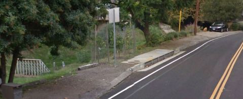
The City of LA recently issued an IS/MND (Initial Study/Mitigated Negative Declaration) and awarded a contract to start work on diverting low flows from certain stormdrains. The low flows – aka urban slobber in some circles – would be pumped from the storm drains into the sewer system, so that they can be treated for pollutants. From there, like the rest of the region’s wastewater, it either gets discharged into flood control channels rivers, is infiltrated to groundwater, or reused (such as purple pipe irrigation). So you can see how it closes some loops and ticks some sustainability boxes.
Through a chainlink fence: the Arroyo Seco back and forth in time
August 12, 2013 § 6 Comments

Fig. 1a. Looking North from Avenue 43. 2013. Hieu Nguyen. Note Southwest Museum on left and a narrowed stream channel.

Fig. 1b. Looking North from Avenue 43. 1901-1916. Minerva Classics. Note Southwest Museum on left, and tracks in streambed used for quarrying during harbor construction.
As part of coursework for Dr. Susan Mulley’s Research Methods seminar in the graduate program in Landscape Architecture at Cal Poly Pomona, Hieu Nguyen chose to examine landscape changes to the Arroyo Seco through the technique of repeat photography. By comparing historical photographs to contemporary views taken from the same location, Nguyen hoped to detect changes in the parkway landscape throughout the years. “I was mainly looking for vegetation changes, urban development, physical deterioration, and obstructed viewsheds.”
Nguyen had treated the Arroyo Seco in a previous Urban Planning project, and was drawn to the topic again because of “the history, design, and uniqueness of the parkway’s scenery.”

Fig. 2a. Looking Northeast from Marmion Way. 2013. Hieu Nguyen.

Fig. 2b. Looking Northeast from Marmion Way. 1935. Los Angeles Times.
Narrowing down available historical photographs to 10-15 that could be feasibly be physically located, Nguyen headed into the field. But things did not go quite as expected. Nguyen’s narrative offers a poignant view at how physical access to the arroyo has changed:
During the trip, I found out that I could not locate all of the camera angles that I intended to shoot due to the urban development, fencing, private properties, etc. For one photo, the walkway was so narrow, I had to grab onto the handrail on the bridge to keep myself balanced while I was taking the photo as the cars were passing by me at 40-50 mph.
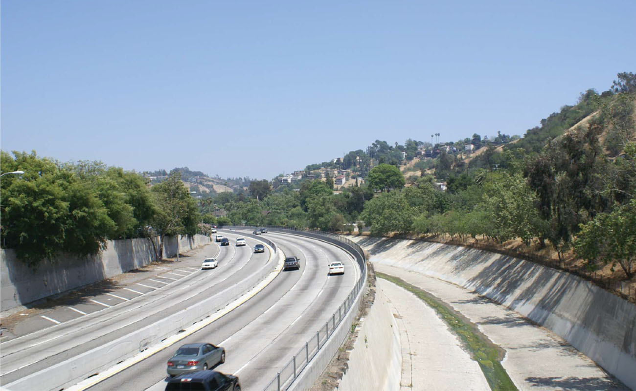
Fig. 3a. Looking Northeast from Pasadena Avenue. 2013. Hieu Nguyen. Note deepening and narrowing of the streambed.

Fig. 3b. Looking Northeast from Pasadena Avenue. 1955. Los Angeles Public Library. Note California sycamores lining the floodplain in the distance.
For another photo, I had to climb down the Arroyo Seco Channel to get the camera angle that I wanted. However, I was not satisfied with the angle and wanted to take it from the other side of the shallow running water way. So I tried to jump across, almost slipped and got myself all wet from knee down. But when I went home and overlaid the historical photo and the current photo, I realized that the current angle was incorrect because the channel bed today was much lower than the historical one due to the flood management and channelization of the Arroyo Seco (Fig 4a).

Fig. 4a. Looking Northeast from Avenue 26. 2013. Hieu Nguyen.

Fig. 4b. Looking Northeast from Avenue 26. n.d. Los Angeles Public Library Herald Examiner Collection.
One of my biggest disappointments was finding a lot of chain link fences on the bridges along the parkway. Because most of my camera shots were taken from the bridges, most of the photos were obstructed by the fences (Fig. 1a). Nonetheless, my professor, Dr. Susan Mulley, and classmates all agreed that the fences were significant landscape changes to the grand viewshed of the originally designed parkway and an important part of my research analysis.
Just as starkly, the historical photographs themselves show a channel that was anything but pristine. Creek Freak co-founder Jessica Hall notes that the Arroyo Seco was once characterized as a shallow and broad river. But even the earliest of the historical photos above already show levees and other substantial encroachments onto the Arroyo’s broad floodplain, which confine flow to a narrowed and deepened channel.
Such encroachments suggest that channelization did not happen in one fell swoop– attempts to control the flow of winter stormwater dated from the beginning of development in the Los Angeles basin and intensified with the changes in stormwater flow regime wrought by devegetation and proliferation of impermeable surfaces. The Army Corp’s famous post-1938 feats of flood control are merely the culmination of this history of efforts at confinement. The final result– a smooth and clean channel so conveniently free of vegetation or anything that might obstruct the swiftest flow of precipitation toward the sea. Gone is the disorderly seasonal dynamism of the original floodplain connecting the foothills to the coast. Channelization creates a streambed as neat as a conveniently placed pipe. One might imagine that streamflow originates from a magical tap in the foothills, rather than from the seeping of precipitation into the soil, and its slow under- and aboveground migration to the sea, which happens to leave in its wake a messy mosaic of vegetation and wildlife habitat.
Nguyen’s photographs also illustrate how armoring of banks with concrete did more than just alter hydrology and habitat. Channelization thoroughly severs any natural functional relationship between various parts of the larger watershed — literally paving the way to the radically featureless flat urban landscape we know today.
A better functioning Arroyo Seco
June 18, 2012 § 3 Comments
Sometimes funny things come in small packages, like an innocent url to a report on the Arroyo Seco. The Urban Land Institute perhaps misspoke when they wrote what makes a stream function better:
The panel concurs with much of the recent work focused
on the naturalization of the stream to enhance ecological
systems and provide unique public amenities. A portion
of the stream on the southwestern side of the stadium
may better function covered, allowing for more efficient
use of the surface for playfield and/or parking, albeit in
an impervious format. (emphasis is mine)
No, it won’t help the stream function better, but it sure could provide for more parking.
The mayor of Pasadena, Bill Bogard, welcomes feedback on the White Paper – take a look! It supports the idea of naturalizing the Arroyo (and hopefully by this we don’t mean a bypass diversion creek but the real deal). The mayor’s email address is bbogaard@cityofpasadena.net.
LA Creeks and Golf Courses – flowing by the fairways
March 26, 2012 § 6 Comments

It seems as though there’s almost always a creek on golf courses in Los Angeles – be it natural, concrete or underground. And having proposed daylighting and restoration projects at a number of our local golf courses, I was happy to see this article, A Stream Runs Through It, published in the Golf Course Industry online magazine, supporting the idea. I have found that golf courses and streams can coexist, but too often golf courses alter the stream, pushing it over the edge of the property, constraining it in ways that destabilize it, removing habitat, etc. The management problems are often quite predictable. The opportunity exists to design a golf course with an understanding of stream habitat and function, leading to a richer golf experience, fewer maintenance issues, and habitat for that remaining 5-10% of LA’s waterways. Streams can separate greens, but when they traverse greens, they can become part of the play in interesting ways.
A couple of golf course/restoration locations I’ve referred to in Creek Freak posts include Devil’s Dip (I promise a post on just the golf course and restoration potential there in the near future but here’s a slide from Creek Freak’s recommendations to Mark Ridley-Thomas about it.) and South Pasadena Golf Course.
A famous creek/golf course is the Arroyo Santa Monica through the Riviera Country Club in Pacific Palisades. « Read the rest of this entry »
Natural Habitat or Grass? South Pasadena Council to Decide
April 1, 2011 § 7 Comments

Photo: Barbara Eisenstein.
And today’s ticking time bomb for the remnant wildness of LA is in South Pasadena, along the Arroyo Seco. South Pasadena is considering taking over some undeveloped land between the Arroyo Seco Golf Course and the Arroyo Seco Nature Park. This undeveloped land has lovely habitat – which you can view in some detail at Barbara Eisenstein’s Wild Suburbia blog. « Read the rest of this entry »
Confluence Plaza Dedication Tomorrow – Wed March 30 2011
March 29, 2011 § 1 Comment

New fountains at Confluence Plaza
Phase 1 of the multi-faceted Confluence Park project is opening tomorrow evening – Wednesday March 30th 2011.
L.A. Creek Freak covered this project’s plans and construction in earlier articles – follow those links for project details. Confluence Park celebrates the historic confluence of Los Angeles River and the Arroyo Seco – the place described in the earliest written account of the Los Angeles area. Today the spot is probably most familiar to Angelenos as the intersection of the 5 and 110 Freeways.
Confluence Plaza, located adjacent to the parking lot of the Cypress Park Home Depot, features fountains, a plaza, seating areas, and landscaping. The Santa Monica Mountains Conservancy, Mountains Recreation and Conservation Authority, Los Angeles City Mayor Antonio Villaraigosa and
Los Angeles City Councilmember Ed P. Reyes invite the public to attend the dedication – tomorrow – at 6pm Wednesday March 30th 2011. See flier for details.
Akiko Crawford’s River Artwork
January 18, 2011 § 3 Comments

4th Street and 6th Street Bridges over the L.A. River - painting by Akiko Crawford
Feast your eyes on this L.A. River art by Akiko Crawford. Click on each image to link to larger versions. Creek Freak ran one piece of hers of in an earlier post, then she recently posted a handful of wonderful river and bridge images, so I figured I’d check in with her and run a bunch here. There’re more, and other urban sketches, designs, renderings, photos and other stuff at Akiko Crawford: Portfolio and Art Blog.

Western end of 4th Street Bridge - drawing by Akiko Crawford
News and Events – 12 November 2010
November 12, 2010 § 2 Comments

Spotted yesterday: pre-striping markings on the Elysian Valley segment of the L.A. River bike path. They're three short white lines in the foreground of this photo. Bike path officially under construction since mid-2009 officially opens on December 4th - announcement below, more details soon.
RECENT NEWS
> The Daily Breeze reports that West Basin Municipal Water District’s desalination plant in Redondo Beach opens today, Friday November 12th 2010. Creek Freak Conner Everts “would like to see them do more conservation, reclamation, and then decide if they need a desal plant.”
> At Spouting Off, Heal the Bay’s Mark Gold reports on promising regional water board votes and efforts to reduce trash in local waters. See also HtB’s Ban the Bag rally below.
> Guess the animals and win a poster from L.A. Stormwater. Deadline is next Wednesday November 17th 2010.
> Will Campell bikes the Arroyo Seco and shoots another great riders-eye-view video.
> L.A. Times Greenspace looks into scary drinking water issues in California’s San Joaquin Valley.
> Congratulations to The City Project’s Robert García on being awarded the American Public Health Association’s Presidential Citation!
UPCOMING EVENTS
> Bike the Los Angeles River from Griffith Park to Long Beach this Sunday November 14th 2010, departing at 7:30am from the Autry Museum. Details at Biking in L.A.
> Heal the Bay invites you to a rally to Ban the Bag – at 8:30am on Tuesday November 16th 2010 supporting the L.A. County Board of Supervisors as they vote to ban plastic bags in county unincorporated areas. Check here for details.
> On Thursday, November 18th 2010 at 7pm, the Arid Lands Institute at Woodbury University presents Morna Livingston speaking on Steps To Water: The Ancient Stepwells of India. It’s part of the lecture series: Excavating Innovation: The History and Future of Drylands Design. The free public talk takes place at Fletcher Jones Auditorium, Woodbury University, 7500 Glenoaks Boulevard, Burbank 91510.
> On Saturday November 20th 2010 from 9am-1pm, the Elysian Valley Neighborhood Council, Council President Garcetti, and L.A. County Public Health host a free Health Fair. The event takes place at the Elysian Valley Recreation Center (1811 Ripple Street, L.A. 90039) and includes a free raffle for a new bicycle, courtesy of the Los Angeles County Bicycle Coalition.
> The Santa Monica Bay Restoration Foundation is holding its monthly Ballona Wetlands Community Open House with tours Sunday November 21st from 9:30-1:00. Guided tours leave at 10am, 11am, and 12 noon. Meet at the Fiji Gateway, 1320 FIji Way in Marina del Rey 90292, across from Fisherman’s Village.
> On Sundays November 28th and December 5th 2010, Jenny Price leads the All-Valley L.A. River Thai Noodles & Cuban Sweets Tour. It goes from the start of the L.A. River in Canoga Park to Griffith Park, and includes the Great Wall of Los Angeles mural on the walls of the Tujunga Wash. Tours go 8:30am-4pm, click here for info and to sign up.
> At 12noon on Saturday December 4th 2010 the Elysian Valley portion of the L.A. River Bike Path will officially open. To emphasize the shared nature of the facility, it’s being called the L.A. River Pedestrian/Bike Path. Creek Freak will post more event information here soon!!
> Duarte dedicates its Encanto Park Bioswale and Outdoor Nature Classroom on Tuesday December 7th 2010 at 9am. Encanto Park is located at 751 Encanto Parkway, Duarte 91010.

Ballona Wetlands Symposium - December 8th
> On Wednesday December 8th 2010 the Santa Monica Bay Restoration Commission will host a free public Ballona Wetlands Science and Research Symposium. It takes place from 8:30am-5:30pm at University Hall 1000, Loyola Marymount University, 1 LMU Drive, LA 90045. For info and to rsvp email Karina Johnston kjohnston [at] santamonicabay.org
Creepy creeks
October 17, 2010 § Leave a comment

Sweet brook or death-trap?
Ever watch Bones? It’s a crime-detection series filmed in LA, standing in for DC. Bones, a forensic anthropologist, and Booth, her FBI partner, get called out to look at skeletal remains of murder victims. From what I’ve seen, it looks like a lot of them end up dumped on the Rio Hondo. Yes, I watch Bones to play “name that stream.” But Bones also reminds me that running across death and decay, the detritus of predator-prey relationships, is a reality if you hike creeks. It’s the shadow side of our life cycle, essential to recycling nutrients for the ecosystem. But still, gruesome. Thankfully I’ve not run across human remains – smashed cars, santeria offerings…but no remains. Knock wood.
Sometimes creeks are just downright creepy.
[Grim photos follow the jump – don’t follow if you don’t want to see it.]
